

Golden Software Strater 5
€ 478,00 * Inkl. MwSt.
* versandkostenfrei per E-Mail
Lieferzeit: 1 - 2 Werktage
Stratigraphically Superior Well Log, Borehole & Cross Section Plotting Software.
komplette Produktbeschreibung lesen
- SKU:
- Artikelnummer: 2910007
Produktbeschreibung
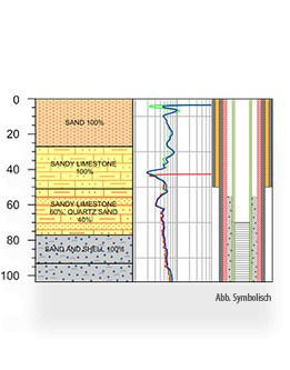
Golden Software Strater ist eine benutzerfreundliche Software zur Erstellung von Bohrloch- und Querschnittsdiagrammen. Mit Strater können Anwender geologische und geotechnische Daten effizient visualisieren und interpretieren. Die Software bietet umfangreiche Anpassungsoptionen, um aussagekräftige Diagramme zu erstellen und geologische Informationen klar und präzise zu kommunizieren.
Vielfältige Importoptionen: Strater ermöglicht den Import von Daten aus verschiedenen Quellen wie Excel, CSV und Textdateien, um geologische und geotechnische Daten leicht zu verarbeiten.
Benutzerdefinierte Diagramme: Die Software bietet umfangreiche Anpassungsmöglichkeiten für Diagramme, einschließlich der Möglichkeit, Achsen, Farben, Symbole und mehr nach den eigenen Bedürfnissen anzupassen.
Bohrloch- und Querschnittsvisualisierung: Strater unterstützt die Erstellung von Bohrloch- und Querschnittsdiagrammen, die es ermöglichen, geologische Schichten und Strukturen klar und präzise darzustellen.
Automatisierte Etikettierung: Die Software bietet Funktionen zur automatischen Etikettierung von Bohrlöchern und geologischen Einheiten, wodurch die Diagrammerstellung beschleunigt wird.
Exportoptionen: Strater ermöglicht den Export der erstellten Diagramme in verschiedene Formate wie PDF, TIFF und DXF, um sie einfach in Berichten und Präsentationen zu verwenden.
Diese Funktionen machen Golden Software Strater zu einem leistungsstarken Werkzeug für Geologen, Ingenieure und andere Fachleute, die geologische Daten effektiv visualisieren und interpretieren müssen.